Ocean movement shapes coastlines and carries energy around the planet.
GRADE 8 SCIENCE
Lesson notes
The ocean stores water, moves energy and connects ecosystems. Waves, tides and currents are different kinds of motion with different causes.
The seafloor is a landscape
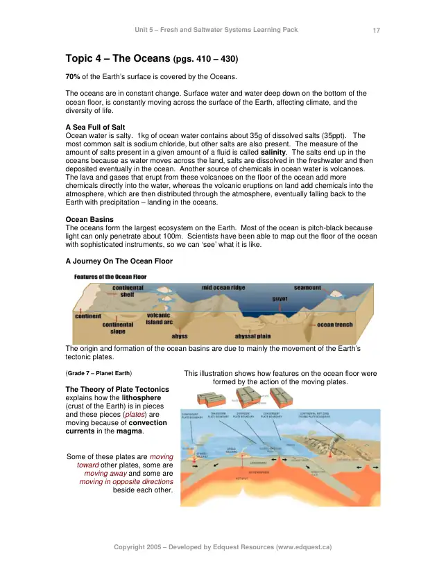
The continental shelf is the relatively shallow submerged edge of a continent. The continental slope descends toward deeper water. Abyssal plains, mid-ocean ridges and trenches are other major features. Plate movements build and reshape these features over geological time.
A ridge is an underwater mountain system, not the deepest part of the basin.
A trench is a long, narrow depression associated with some plate boundaries.
The oceans connect; named ocean regions are parts of a global system.
Why is seawater salty?
Weathering releases dissolved substances from rocks. Rivers carry ions toward the ocean, and exchanges at the seafloor also contribute. Evaporation removes water while leaving most salts behind. Salts also leave seawater through biological and geological processes.
Typical open-ocean salinity is about 35 g of dissolved salts per kilogram of seawater, but it varies.
Rainfall, river input and melting ice can lower local salinity.
Evaporation and sea-ice formation can increase the salinity of remaining water.
Waves: energy passes onward
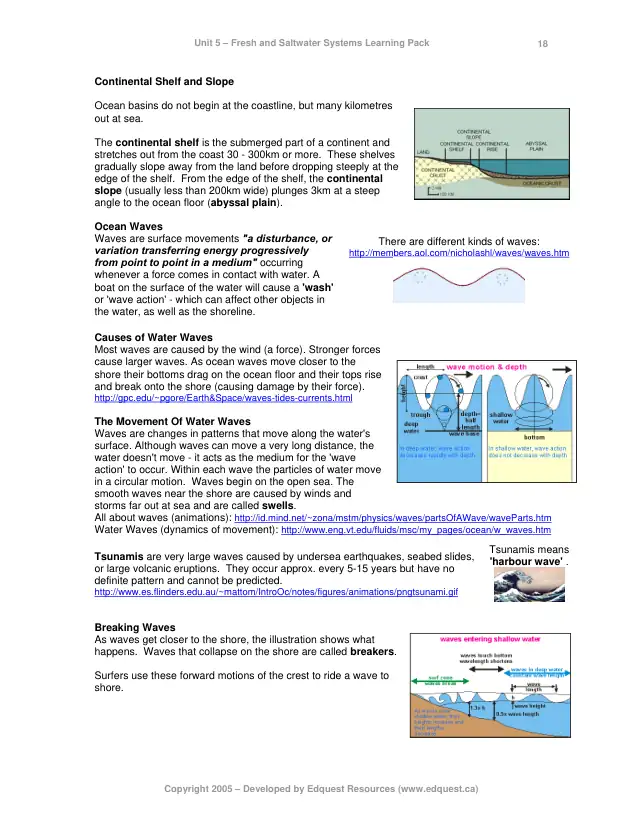
Wind can transfer energy to the surface. A crest is a wave’s high point; a trough is its low point. Wavelength is the distance between successive crests. In an ideal deep-water wave, water parcels move in near-circular paths while the wave pattern travels.
Amplitude is measured from the undisturbed surface to a crest.
Breaking waves near shore can move water and sediment more directly.
The motion of one floating object can combine waves, currents and wind effects.
Tides: a changing sea level
Tides arise mainly from Moon–Earth–Sun gravitational interactions and Earth’s motion within that system. Spring tides tend to have a larger tidal range when lunar and solar effects reinforce. Neap tides tend to have a smaller range when those effects are less aligned.
Spring tide is not named after the season.
Tidal range is the difference between high and low water levels.
Coastline shape, basin depth and other factors affect local tides. Use a local tide prediction for a real location.
SEE IT EXPLAINED
Why are there two tides a day?
Use the animation to explain the two-sided tidal effect. Then distinguish the ideal picture from actual tides near coastlines.
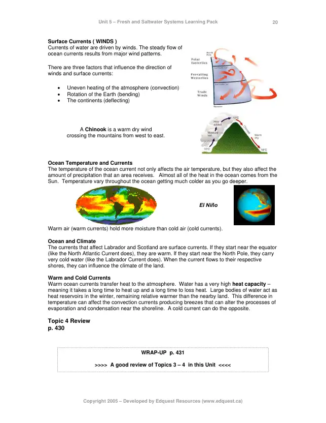
Currents carry water, heat and other materials. Surface winds and Earth’s rotation help shape large-scale surface circulation. Differences in temperature and salinity affect density and contribute to other circulation patterns. Colder or saltier seawater is generally denser under comparable conditions.
A warm current can transfer energy to the atmosphere and influence a coastal climate.
A surface-current map does not show every flow at every depth.
A single cause rarely explains the whole circulation.
Shorelines keep changing
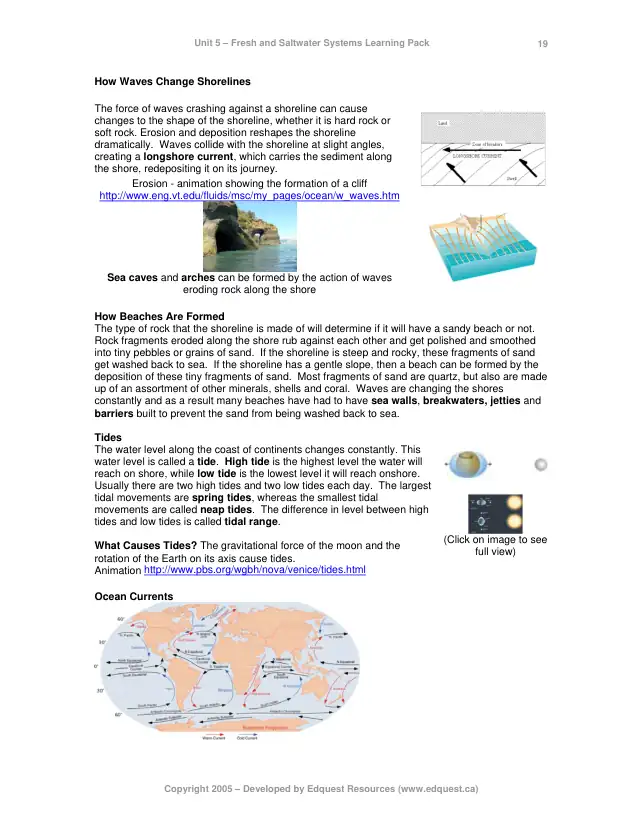
Waves and currents can erode a coast, move sediment and deposit it in a different place. The amount of sand on one beach can change with storms and seasons. Coastal structures can alter sediment movement and affect neighbouring stretches of shore.
Missing beach sand may have moved offshore or along the coast.
Compare dated observations and the wider coastline before explaining a change.
Do not mix up the three motions
Motion
Main idea
Look for
Wave
Energy travels through a disturbance
Crests, troughs and oscillation
Tide
Sea level changes over a cycle
High water, low water, tidal range
Current
Water flows from place to place
Persistent transport / drift
A WORKED EXPLANATION
A buoy moves in two ways
A buoy rises and falls repeatedly as wave crests and troughs pass.
Over several hours, it also moves along the coast.
The short-period motion is consistent with waves; the longer drift could include a current and wind on the buoy.
Use additional measurements before treating the buoy’s path as a complete current map.
Relevant pages from the original review pack. Use the updated explanations and linked sources for estimates and terminology.
EARTH · OSCAR SURFACE CURRENT ESTIMATES
Explore ocean currents across the globe
Drag to rotate the globe. Select a point in the ocean to inspect the estimated current. Open the earth menu to check the displayed date and data layer.
Investigate
Find the Atlantic. Compare the Gulf Stream near North America with the flow nearer the middle of the basin. Then rotate to the Pacific.
Read the limits
These are model-derived estimates of near-surface currents, not every current at every depth. The animated traces indicate flow, not the measured paths of individual objects. Check the date; do not assume the layer is live.
PHET · WATER WAVES
Make ripples and compare their spacing
Choose Waves, select the water tap icon, and press the green button on the tap. Start with Side View to see crests and troughs. Switch to Top View to see ripples spreading: the moving bands represent changing water level, not a current.
Change one thing
Keep the medium and amplitude fixed. Increase frequency. Compare the distance between successive crests: wavelength decreases when wave speed stays fixed.
Separate wave from current
A ripple pattern travels outward. A current is net movement of water. This overhead ripple model does not track a floating object or model breaking ocean waves.
WATCH THE PHENOMENON
How do ocean currents work?
TED-Ed · Animation
Explain a journey across the ocean
Identify a wind-driven current and a density-related process. Explain why floating objects need not stay together.
The current transports relatively warm water, which can exchange energy with the atmosphere. Regional effects also depend on winds and geography.
Key connections
Wind & density
Water motion
Heat transport
Coastal effects
TRY IT
Try it yourself
A beach loses sand after a storm. Has the sand necessarily vanished?
Give me a hint
Trace erosion, transport and deposition.
Compare with a worked response
No. Waves and currents can carry sand offshore or along the coast and deposit it elsewhere. Measurements are needed to determine where it went.
TAKE IT FURTHER
Make the connection
Why is a warm ocean current relevant to a coastal climate, even though it is not a wind?
Compare your reasoning
The current transports relatively warm water. Energy can pass from that water to the atmosphere, and winds can carry that energy toward land. Geography and atmospheric circulation affect the result.